This project was to develop new digital reconstructions depicting the early settlement of Nassau, Bahamas, during the Golden Age of Piracy around 1715. The images were commissioned for the YouTube documentary channel Wreckwatch TV and were a collaboration with fellow historical reconstruction artist Robert Gapper of Virtual Histories, and our client, Dr Sean Kingsley and in collaboration with the New Providence Pirates Expedition and Wreckwatch TV. Working with limited historical evidence, we attempted to visualise what the early settlement and its fortification might have looked like using detailed 3D models and game engine technology. The animations can be viewed by following the link at the very bottom of this page.
Production notes
Our workflow
All of our models were constructed using the open-source software Blender 3D. These were then assembled together in Unreal Engine 5. Unreal Engine is a real-time game engine with cinematic-quality rendering capability, yet it offers considerably more than a rendering pipeline. We wanted to develop an added-value solution that offered and demonstrated far greater scope and potential than creating a sequence of animations and static images. We chose to recreate Nassau as an immersive virtual environment from which we could select various views to produce a sequence of animations and, potentially, output other multimedia experiences in the future. Our approach provides a living digital environment that can be continually adapted and added to long after the initial deliverables are complete. The project has demonstrated its value as an immersive visual experience, with huge potential for future use in museum displays, classroom resources, virtual tours, guided interpretation, and interactive learning. Each of these possible outputs can draw on the same reconstructed environment without needing to rebuild it from scratch, making our solution an invaluable heritage asset.
The project called for a blend of maritime and architectural themes set during the Golden Age of Piracy. Sean conducted the bulk of the research and provided me with detailed briefing notes. The modelling tasks involved creating vernacular architecture, sailing ships and smaller landing craft, shipwrecks, jetties, warehouses, pirate camps, looted goods and supplies. We also had to create a range of figures – the pirates, to include women and formerly enslaved people whose historical records are fragmentary at best. Reliable visual references for this period are scarce, and we were determined to avoid the romanticised pirate imagery adopted by contemporary films and television series. Sean Kingsley sourced a range of visual and anecdotal material that helped ground our work in historical reality rather than popular cliché.
The project presented us with some interesting technical challenges. We needed to accomplish as much of the work as possible with only a small team. I appointed Welsh reconstruction artist Robert Gapper as co-creator. I have long admired Robert's virtual reconstructions of Romano-British sites, and his skills with Unreal Engine made this the most efficient way to tackle the project. This meant that I could focus on modelling all the individual digital assets and props for Robert to add to his scenes in Unreal Engine. We hired the skills of artist and digital clothes creator Ina Haiduk (Naama) to produce period-accurate clothing for our pirate characters. We modelled the landscape, all the architecture, ships and small boats, characters, and scene assets ourselves. The only 3D assets we purchased were native plants, a few animals and birds, and sourcing some of these so they could be animated proved quite a challenge!

Architecture: Reconstructing the Artillery Fort
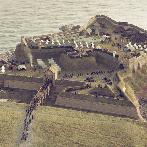
A stockaded fort was built in 1697 under the orders of Nassau's Governor Nicholas Trott, supporting 26 4-12-pounder guns. The earliest Caribbean forts appear to have been built under local guidance, rather than by professional engineers with funds and manpower provided by the island's planters. The fort was damaged when the Spanish raided Nassau in 1703. Its guns were either stolen or spiked (rendered unusable), the town and church were burned, and the island's inhabitants plundered. During the pirate occupation, Benjamin Hornigold, founder of the "Republic of Pirates", undertook to maintain the fort, but it's unlikely the pirates made any substantial repairs, as in July 1718 the fort was recorded as in a very run-down state, with one bastion fronting the sea collapsed. It is likely that the fort's foundations were constructed of stone, because in August 1718, New Providence’s Council discussed the burning of lime with haste for the "necessary repairing [of the] the Breaches of the Fort required."
Nothing remains of the fort today – its location is now occupied by the British Colonial Hotel. The only reliable plans we have of it date from 1770, 55 years after the pirates' occupancy, and this depicts the repairs carried out long after the pirates were evicted. The plans were obtained from the National Archives, and are not in the Public Domain, so I am unable to publish them here. I've used these as my general reference for the reconstruction, although it is entirely possible that the earlier fort may have had a simpler design and form.
With only vague descriptions of the artillery fort's pre-1718 pirate-era state to inform my reconstruction, I first tried to visualise the fort as it might have looked in pristine condition, with stone ramparts and bastions, and timber battlements reinforced with earth and sand. I then used features in 3D software to simulate damage and deterioration. This was quite a fun, though surprisingly fiddly, challenge because creating the damage added extra complexity to the model geometry, making it harder to edit and alter later in the process.

Architecture: Reconstructing Nassau's Settlement
The modern city of Nassau, capital of the Bahamas, is dominated by busy passenger cruise ship and freight-handling terminals. It serves as a central hub for commerce, nightlife, and tourism, with many hotels, shops, restaurants, beach resorts, and other facilities attracting millions of tourists every year. It bears little or no resemblance to its late seventeenth and early eighteenth century form and layout. The earliest reliable maps date from almost a century after the pirate occupancy, which begin to show the formation of an organised street plan and identifiable buildings. Visualising how the town looked in 1715 required a stretch of the imagination, but the early maps at least helped us pinpoint the location of the fort, around which we could hypothesise about the locations of other buildings. The shorefront in 1715 would most likely have comprised a range of storehouses, two or three taverns, and a few higher-status buildings – perhaps accommodation for the town's governors. A range of simpler dwellings would have sprung up around this nucleus.

Homes were modest cabins constructed from Caribbean pine or Lucayan cedar, featuring simple shutters, wattle-and-daub walls, and palmetto-leaf roofs. Cooking generally took place outdoors to minimise the risk of fire. Images, drawings, and paintings of local vernacular buildings from the nineteenth century served as references and inspiration for the reconstruction of my 3D architectural models. Given how slowly Nassau’s architectural character appears to have developed, and considering the climate and availability of local building materials, it is reasonable to assume that its earliest structures were similarly rudimentary.


No reliable visual records survive of Nassau’s original church beyond its timber construction and destruction during the 1703 Spanish raid. I modelled a complete timber church based on colonial examples, then partially destroyed it, electing to preserve the bellcote and porch. Retaining those elements is likely artistic licence rather than historically accurate; however, I wanted to show something that is partially recognisable as a church, purely to aid communication.
Modelling the ships and smaller vessels
Nassau’s shallow bay and prominent sandbar meant that larger vessels could not enter the harbour directly, which conveniently spared me from tackling the complex task of modelling warships, galleons, and frigates. Instead, I concentrated on the smaller, more manoeuvrable craft favoured by pirates: brigantines, sloops, pirogues, canoes, and skiffs. I also depicted a careenage beside the fort. Careening was the practice of beaching a vessel at high tide, tilting it onto its side, and carrying out hull repairs at low tide - a vital maintenance procedure in Caribbean waters, where wood-boring shipworms (Teredo) posed a constant threat to wooden hulls. In a remote location like Nassau, with few dedicated facilities, beaches served as improvised careening wharves.

The ship models had to look convincing, so I included many details, such as rigging, ropes and tackle, sails, cannons, swivel guns, and other deck items. However, faced with a strict time limit for developing each model and in order to maintain clean, efficient geometry, I had to employ some clever modelling shortcuts and workarounds. Image textures carry much of the detail, which meant I could reduce the polygon count of some of the more complex vessels. Many of the models are also modular, meaning I can produce multiple derivatives of a single model by making a few subtle changes to its geometry, creating the illusion of variation. The simple technique of alternating textures between models often makes any visible similarities appear less obvious when viewed from a distance.

Adding life to the reconstructions
We developed over forty individual character models to add life to the reconstructions. These included male and female pirates and former slaves. These began as conceptualised sketch drawings using Procreate on my iPad, and I then handed these visual references to Ina Haiduk (Naama) to produce the clothing in Marvelous Designer. I applied textures to the clothing using Substance 3D Designer and Substance 3D Painter. Robert attached the clothes to the character models he had made in Character Creator, brought them into Unreal Engine, and added simple animations and behaviours to bring them to life.

Conclusion
The project challenged my assumptions about how the settlement was arranged. Early Nassau was far more dispersed and informal than the later town plans suggest. Since the earliest surviving maps postdate the pirate era, the precise locations of most buildings are the subject of speculation. That uncertainty was at times uncomfortable, but the lack of evidence simply did not support firmer conclusions. Overall, the Nassau Piratetown project was a rewarding experience both for the collaboration it involved and for the historical, technical, and artistic knowledge I developed along the way, all of which will inform my future projects.
The final animations can be viewed on the Wreckwatch TV YouTube channel. Please note that Wreckwatch has used Generative AI content in other parts of their production. We had no involvement in the creation of any images or content using generative AI technology. All of our reconstructions were created using the methods described in the article above.
Supporting information sources and references
Researched by S. Kingsley, B. Marshall (2025)
- Bahamas. Historical Memorandum Relating to Forts in New Providence (New Providence, 1913).
- Tessa C. S. Machling, Protected interests? The fortifications of Nevis, West Indies, from the 17th century to the present day (PhD Thesis Department of Archaeology Faculty of Arts University of Southampton September 2003).
- Craton, A History of the Bahamas.
- Plan: Fort Nassau WO 78/2558/3, Unknown Date - The National Archives.
- Plan of Fort Nassau and Fort Montague. Enclosed in f. 5. CO 23/8/15, 1768 - The National Archives.
- M. Craton & G. Saunders, Islanders in the Stream. A History of the Bahamian People. Volume One: From Aboriginal Times to the End of Slavery (University of George Press, 1999).
- Woodard, C., The Republic of Pirates: Being the True and Surprising Story of the Caribbean Pirates and the Man Who Brought Them Down (Harcourt, 2007).
- Konstam, A., The Pirate Menace (Osprey, 2024).
- Johnson. C., The General History of the Pyrates (London, 1725).
- Konstam, A., The Pirate Ship, 1660-1730 (Oxford, 2003).
- Little, B., The Sea Rover’s Practice. Pirate Tactics & Techniques (Potomac Books, Inc., 2005).
- Moore, D.D., ‘Captain Edward Thatch: A Brief Analysis of the Primary Source Documents Concerning the Notorious Blackbeard,’ The North Carolina Historical Review 95 (2018), 147-187.
- Moss, J., The Life and Tryals of the Gentleman Pirate, Major Stede (Köehlerbooks, 2020).
- The Ship. Björn Landström (Allen & Unwin, 1961).
How this image was made
Software and tools used: Blender 3D, Unreal Engine 5, Substance 3D, Photoshop, Procreate, Marvelous Designer, Character Creator, iClone, DaVinci Resolve.
About the images in my portfolio
You may notice subtle shapes and patterns in some of the images in my online portfolio, affecting their visual quality. I am experimenting with free tools developed by researchers at the University of Chicago to help artists protect their work from unauthorised AI training. It subtly alters images in ways that are almost invisible to people but can confuse AI models, making it much harder for them to learn and reproduce an artist's distinctive style.
Commissioned Work
Artist:
Bob Marshall and Robert Gapper (Virtual Histories). 2026
Contributing Artists:
Ina Haiduk (Naama)
Project consultants:
Sean Kingsley, Chris Atkins, Michael Pateman
Client:
Dr Sean Kingsley, Wreckwatch Int.
Image rights owner:
© Dr Sean Kingsley, Wreckwatch Int.
Please seek the permission of the owner to use or display this image elsewhere.
My 3D models cannot be shared or licensed for other use due to contractual agreements with my clients and, in some cases, other stakeholders. More information can be found on my Licensing information page.
Bringing your imagination to life after detailed archival research can be daunting. In the hands of Bob and his team, our vision was taken beyond our high expectations. Using detailed remits into topography (LiDAR), historical sources for architecture, ship types, pirate clothing, island vegetation and animal populations, Bob created the first historically realistic image of one of history’s great places. Nassau has been explored, romanticised and misunderstood by Hollywood, TV and video games for over 100 years. Now, it is back on the map in a brilliant, stylish and historically viable 3D model. Working with Bob has been a total delight from start to finish. His immense skills and experience are recommended with great pleasure.
Dr Sean Kingsley. Director
Wreckwatch Int.